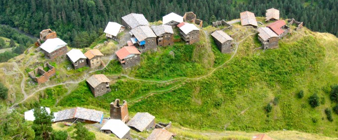
Tusheti - one of the most picturesque and historic provinces of Georgia, is located in Kakheti region, to the north of the Greater Caucasus watershed. Tusheti is bordered by Chechnya and Dagestan to the north and east (both the Russian Federation republics) and by Georgian historic provinces – Kakheti, Pshavi and Khevsureti to the south and west. The total area makes 825 sq. km. The highest point above sea level is the peak of Tebulo Mountain (4492 m), the lowest is the Tushetis Alazani River (1490 m) – near the border of Dagestan.
Surrounded by high ridges and summits, Tusheti is furrowed by numerous ravines fed by cascading streams and waterfalls, all flowing into the two main rivers of Tusheti – Pirikiti Alazani and Gometseri Alaziani. Both rivers converge at the Shenako Village to flow further under the name of Tushetis Alazani to Dagestan, where it is called Andis Koisu.
Because of geographic isolation and remoteness from the historic centers, rather few historical narratives about Tusheti were preserved up to the late Middle Ages. However, the outstanding scholar of the 2nd century AD Claudius Ptolemy in his Geographia mentions Didurebs and Tusks living in the Caucasus mountains. It is considered to be the first mention of the Tushs in historical sources. On the basis of archeological materials, Georgian historical literary sources and folklore data, continuous being of Tusheti in the composition of the Georgian state and the presence of Georgian life therein is being evidenced since the 4th century.
Flora of Tusheti is characterized by a surprisingly high level of endemism. 230 representatives of the local fauna are the Caucasus endemics (over 20 percent of the total Caucasus endemics). Also rather wide is the list of diverse animals and birds found in the Tusheti National Park: Caucasian goat, chamois, bezoar goat, red deer, brown bear, black grouse, eagle, Caucasian snow-cock, bearded vulture, etc.
Historically, Tusheti comprised four mountain communities: Pirikiti, Gometseri , Tsovata, and Chaghma. The administrative center of Tusheti – Omalo belongs to the Chaghma community. The motor road leading to Tusheti starts from the Village of Pshaveli in Kakheti and by going through the highest drivable mountain pass – Abano Pass (2950 m) ends in Omalo. Abano Pass is open only for several months in the year, during which it has to be constantly cleaned from landslides and slide-rocks.
Tusheti can be reached from Kakheti by foot, horse, cross-country vehicle or helicopter.
Different tourist routes have become popular lately in Tusheti, in particular kinds of adventure tourism and agrotourism. The tourist infrastructure and services are gradually developed, also the number of local and foreign visitors is increasing annually. The fact that 3 major tourist routes connecting Tusheti with Kakheti, Pshavi and Khevsureti go through the “Alaznistavi” enterprise in Gometseri gorge is worth mentioning.


